
Home
FACs
More About FACs
The AO
A Shau Valley
• A Shau SF Camp
Hué
• Hué Cit Airfield
• MACV Compound
• LCU Ramp
• Hué Goose
Battle of Hué (Tet 1968)
• Trail FACs
The Missions
Visual Recon
• Sunken Sampan
Close Air Support
• CAS Munitions
• Rules of Engagement
• TACS
• Battle at Hua Cu
Interdiction
• McNamara Line
• Choke Points
Ranch Hand
Trail Dust Mission
Arc Light
SAR
Hammer 51 Rescue
Search for Jolly 23
• Msn Reports
• Search Area Map
• Search Rejoined
• Link to Past
Jungle Penetrator
Legacies
Aircraft
O-2A
Glossary
Resources
Contact
Return to Top
Return to Top
|
| |
Choke Points
Interdiction operations focus on those areas where the geography funnels the traffic into a narrow, confined space.
Usually defined by some combination of steep terrain and a water barrier, these funnels tend to naturally impede the flow of traffic and cannot easily be bypassed.
Such "choke points" (also called Interdiction Points) were, to paraphrase bank robber
Willie Sutton, "where the targets are."
Aircrews worked these choke points nearly around the clock.
At night when most of the truck movement occurred, FACs using
Starlight scopes (early night vision devices)
spotted and marked truck convoys for attacking aircraft.
Gunships -- AC-119G Shadow and AC-119K Stinger
and later AC-130 Spectre -- provided a
self-contained targeting and kill capability.
B-52 Arc Light missions also were used against choke points and other
known supply concentrations, particularly in bad weather.
During daytime, FACs looked for hidden truck parks and directed airstrikes for road and bridge cuts to impede the flow of supplies.
It was a dangerous, tedious, never ending job.
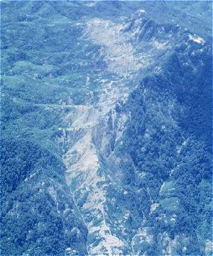
The photo of "The Falls" choke point in Laos (top of this page) is a classic example of an attempt to cut a road by air.
The narrow defile in the center of the image has been heavily bombed
in an attempt to block the road with craters and landslides.
Raven FAC Jim Roper, who took the photo, said this about the area:
| |
Choke points or IDPs (Interdiction Points) were heavily defended.
The Falls had at least a dozen 23-mm and half a dozen 37-mm guns.
They were most active at night during the dry season (Nov-April).
They would let a maneuvering FAC make a daytime pass overhead at 3500' (and take this photo) because they believed their camouflage to be good, and it was, and
they knew they'd be attacked if they missed.
Generally, Covey [FACs] approached these choke points in a wide circle and departed by expanding the radius of the circle, not turning away.
|
|
Read more about The Falls and the air war over the Ho Chi Minh Trail in Jim's book Quoth the Raven.
Every time we would succeed in cutting a road such as this during the day, we would return the next morning to find the road rebuilt and indications of heavy traffic having passed (as in the photo above).
The cycle would then start again.
Click here to locate The Falls in southern Laos
A Shau Valley Choke Points

Southern Choke Point, A Shau Valley (1968)
© Tom Pilsch
|
The southern choke point in the A Shau Valley was located at a narrow part of the valley floor where the road crossed the river.
Repeated bombings turned the area into a quagmire making it difficult for truck traffic to progress.
In some of these wet areas, soap-like material was scattered to make the mud even more slippery and difficult to traverse.
The best we could hope was to slow the movement of supplies and make it more costly for the enemy. We never totally stopped the flow.
We were dealing with a resourceful enemy. At a point at the northern end of the A Shau Valley where the road snaked around the
side of a mountain, we made repeated (but only temporarily successful) attempts to drop the road down the side of the mountain.
Each time, the road would be rebuilt by the next morning and heavy traffic had passed over the repairs.
Tiger Mountain, north end of A Shau Valley (1968)
© Tom Pilsch
|
One time we had fighters put in bombs with time-delayed fuses along this stretch of road. The bombs were set to go off at hourly intervals during the night.
The next morning, the same story: road repaired, heavy truck tracks. Tough little rascals.
The trick was to find the bulldozer and other equipment they were using, but we were never able to do that from the air during my tour.
A major Marine operation into the northern A Shau Valley in early 1969 (Operation Dewey Canyon) did find and destroy a bulldozer along the road in this area.
|
|
Visual Reconnaissance
Interdiction
Close Air Support
|
