65th Air Base Wing
Click for Lajes Field Weather
Azores Archipelago
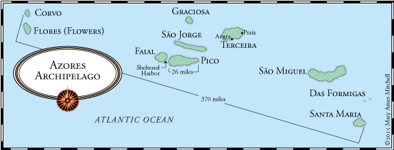
Map used with the kind permission of Mary Ames Mitchell from Crossing the Ocean Sea

Some of the links from this page are in Portuguese.
Click here for Google Translate, then copy & paste LINK.


Azores

  • The Complete Guide to the Azores
  • The Azores (Wikipedia)  • Location  • More
       • Government  • More  • More (Crossroads, 24Sep04)
       • Atlas of the Azores
  • The Nine Islands (plus links)  • More  • More  • More
  • Untamed Island Paradise (Washington Post, 2015)
  • Azores Portal (w/ interactive map & photos)  • Another
  • Azores Map  • Map  • Map (small)  • Maps of 9 islands
  • Azores History  • Historic Maps  • Azores Map (1584)
  • Holy Ghost Festivals (all islands)

  • Crossing the Ocean Sea (Atlantic exploration)
       • The Terceiran Explorers - Corte Real and Fernandes
       • Map: Atlantic currents & naviagtion routes
       • Claiming the Azores: The Flemish Connection
  • The Corte-Real Family  • Miguel  • Gaspar
  • Azores History  • More  • More  • More  • More
  • Columbus in the Azores
  • Azoreans to California (e-book)
       • Stories of Californian Azorean Immigrants
  • Historical Photos of Azorean Life  • More
  • Azorean Birds
  • Azores Volcanology  • Pt. 2  • More  • More
  • History of Aviation in the Azores
  • NC-4 Across the Atlantic via The Azores (1919)
       • Flight Details (photos, maps)  • More  • Photos
  • Pan AM Clippers in Horta (first arrival: 27 Mar 39)
       • Clippers at Horta  • More in series (scroll right)  • More
       • Transatlantic Flight Schedules & Details
  • The Azores in WW I
  • The Azores in WW II  • More
       • War Plan Gray (contingency to invade, 1940-41)  • More
       • Gibraltar-Africa Project (German interest in Azores, pp 75-77)
       • Operation Alacrity (code name for Allied presence)
       • Oprn Alacrity: The Azores and the War in the Atlantic

  • Genealogy and the Azores Islands
       • Faial Genealogy

  • Azores Travel (The Perfect Tourist)  • More
  • Getting to the Azores from the U.S.
       • Direct Flights From North America
          • Destinations: Terceira  • San Miguel (Ponta Delgada)
  • Things to see & do
  • TripAdvisor: Azores
      • TripAdvisor Topic: Ferriy Travel in Azores
          • Booking Agent  • Another • Another
  • Cruising the Azores
  • Azores Cruise Ports (detailed)
  • Things to Know Before Traveling to the Azores
  • Island tours

  • Airports in the Azores (aeronautical data)

    Geology & Volcanology of the Azores
  • Azores Volcanology  • Overview  • Basics
       • Volcanological Chart (Terceira)
       • N Atlantic Volcanos    • Mid-Atlantic Ridge    • Azores
       • Techtonics  • More  • Azore Triple Junction
       • Sáo Miguel  • Terceira  • Sáo Jorge  • Faial  • Pico
          • Corvo
  • Smithsonian Global Volcanism Program
     • Corvo  • Faial  • Sáo Miguel
  • Capelinhos Volcano Eruption - Faial (1957-58)  • More
  • Submarine Volcano west of Terceira
       • Lava Balloons  • Photo


    The Islands

  • Santa Maria  • More
       • History & Culture of Santa Maria (Crossroads, 12 Mar 04)
       • Map  • Photos
       • Santa Maria Airport (LPAZ)  • More

  • São Miguel  • More  • Map  • Photos
       • History & Culture of São Miguel (Crossroads, 19 Mar 04)
       • Ponta Delgada  • More  • Map
          • Senhora Santo Cristo Festivals

  • Terceira (internal link)  • Map  • Map  • Photos

  • São Jorge  • More  • Map  • Photos  • Aerial view
       • History & Culture of São Jorge (Crossroads, 8 Apr 04)
       • Historic Map (c 1861)
       • São Jorge Airport (LPSJ)  • More

  • Pico  • More  • Map  • Photos
       • History & Culture of Pico (Crossroads, 16 Apr 04)
       • Lajes do Pico  • Photo  • Aerial view
  • Mount Pico  • Snowcapped (from Horta)  • More
  • Forts of Pico (Fortificação - Ilha do Pico: em português)
       • Fort of Santa Catarina  • More

  • Faial  • More  • More  • More  • Map
       • History & Culture of Faial (Crossroads, 23 Apr 04)
  • Faial History  • More  • More
       • Photo (late 19th C ?)  • 1919
       • Battle of Fayal (Faial) (26-27 Sep 1814)  • More
  • Geological Photo Tour of Faial
  • Horta  • More  • History  • Map  • Closeup Map  • Photos
       • Port of Horta  • Port information  • Harbor Chart
       • Horta Airport (LPHR)  • More
  • Sightseeing in Horta  • Pt. 2
  • Forte de Santa Cruz  • History  • Plan
       • Aerial view (now Posada of Horta)  • Harbor View
       • Pousada Forte de Santa Cruz
  • Horta Marina  • More (w/ aerial view)  • Quay art
  • Fort of São Sebastião da Horta (w/ aerial photo)
  • Peter Cafe Sport (Horta)  • History

  • Graciosa  • More  • Map  • Photos
  • Forts of Graciosa (em português)

  • Corvo  • More  • Map  • Photos
       • Corvo and Airport (LPCR) - aerial view  • Airport

  • Flores  • More  • Map  • Photos
       • History & Culture of Flores (Crossroads, 30 Apr 04)
       • Flores airport (LPFL)

  • Columbus in the Azores
  • Terceira

  • Terceira - Background  • More
       • Terceira History & Culture (Crossroads, 26 Mar 04)
       • Aerial Photo (east to west)  • Map  • Map
       • Map: Terceira Pariishes
       • Terceira Map (1:50K, 1943)
       • Aeronautical Chart
  • Terceira Photos  • More  • More  • More  • More
       • Terceira Vistas (slide show)  • More
       • Beaches, swimming "pools," scenes
       • A tunnel of hydrangea (central Terceira)
       • Goat Rock (a.k.a. Split rock)  • More (land side)  • More
  • Exploring Terceira's Caves (Crossroads, 4 Jun 04)
  • Terceira Festivals  • More Detail  • Video clips
  • Street Bullfighting: Bullfighting on a Rope
       • Street Bullfighting (Crossroads, 14 May 04)
       • Video (c 2008)    • Video (c 1980s)
  • Portuguese arena bullfighting  • Photo  • Finale
  • Terceira Photos & History
  • Island Photos, c1960's (Lajes HS Alumni Assn.)
  • Forts of Terceira (Wikipedia)  • More (old drawings; Pt)
       • Interactive Map (zoom in to Azores, most dots = Terceira)  • DB
  • Battles of Salga and Praia da Victória
  • Battle of Salga (25 Jul 1581)  • More  • More  • Image
       • Sao Sebastiao today
       • Legend of Brianda_Pereira
  • Battle of Praia Bay (11 Aug 1829)  • Image
       • Battle of Pria Bay (detailed graphic)
          • #22: Forte Santa Caterina (internal)

  • Terceira Island Travel Video  • Another  • Pt. 2
  • Terceira Travelogue (good geographical overview!)
  • Terceira Travel Map (interactive: island highlights)
  • Terceira Restaurants (TripAdvisor)
  • Flying to Terceira (Lajes, c Jan 2017)
  • Sites to visit on Terceira (Crossroads, 12 Mar 04)

  • Angra do Heroísmo  • Classic View (c 2008)
       • History  • Map  • Map w/key  • Google Map
       • Harbor Map  • Aerial Photo (2016)  • 1918  • c 1850
  • Angra: UNESCO World Heritage Site
       • More  • Photos  • Historic Map (c 1832)
  • Forte de São João Baptista (Monte Brasil)  • Fort
       • Aerial view  • Maps  • SW Face  • S Face  • SE Face
       • East side  • North side  • West side  • West side aerial
       • c 1850 (showing signal tower)  • Military signals history
          • Monte Brasil Signal post, Angra do Heroismo
  • Forte de São Sebastião  • More  • Photo
  • Fort of Greta (Forte da Greta, ruin)  • Map
  • Angra Walking Tour  • Map  • Another Tour  • Another
       • Accessible Tour (w/ photos)
  • Angra: Satellite View (Google Maps, interactive)
  • Angra Description & City Map
  • Angra Points of Interest (click for descriptions in English)
  • Things to Do in Angra (good photos!)
  • Praca de Toiros (bullfighting areana)  • Inside

  • Praia da Victória  • More  • History  • City Map
       • Aerial Photo (2007)  • More  • Port Map
       • Paria Bay & Port from Serra do Cume
       • Pria Bay, north end (aerial)  • Satellite view (2017)
       • Pria Bay (west from Imaculado Coraçâo de Maria)
       • Port of Pria (at Cabo da Pria)  • Docks (aerial)  • More
       • Praia Marina under construction (2001)
  • Pria: Satellite View (Google Maps, interactive)
  • Map: Municipality of Pria da Vitoria (detailed!)
  • Architecture of Praia (detailed, in Portuguese)  • Color Key
  • Map of Praia & Praia Bay (c 1805)  • Source
  • Forte de Santa Catarina (Cabo da Praia)  • en Portuguese
       • Photo  • Satellite view

  • Praia & Lajes Field (aerial view looking NE, c 2000)
       • Civil Air Terminal (west side of runway)  • More

    Lajes Field

  • Lajes Field  • Background  • Analysis  • More
      ú • Base Map
       • Airport Diagram (LPLA)  • Aeronautical Details  • Photos
       • Civil Air Terminal (west side)  • More  • More
       • Lajes Field: Satellite View (Google Maps, interactive)
       • Aerial Photo (click image to expand)  • Satellite
       • Rwy 33 (aerial)  • Same sortie!  • Rwy 33 Approach  • Video
       • Rwy 15 & ramp (aerial, c 1989)
       • Base (aerial: S)  • Base (aerial: SW)  • Base (aerial: W)
       • Base: aerial looking SW toward Angra  • Aerial looking E
       • Flightline looking S  • Same, c 1960  • Same, c 1943
       • Flightline looking NW  • More  • c 1945  • c 1955 (B-36's ?)
       • Navy Ramp  • POL Tanks    • Refilling POL tanks from ship
       • Military Port Facility, Pria Bay (1991)  • More (c 2014)
       • AWOL Rock  • More  • In rough seas  • Story
       • Control Tower  • Closeup  • Flightline toward tower

       • Air Traffic At Lajes (photos)

  • Lajes Field History
  • Lajes Field History (Ed Lima, 65ABW Historian, 2012)
          • Abbreviated  • Another
          • Lajes Origins
          • U.S. Enters Lajes Field  • Joint US/RAF Markings  • More
          • Santa Maria & Beyond
          • Lajes 1950's-1960's
          • Lajes in the 1973 War  • More
          • Humanitarian Efforts: 1980s-1990s
          • The Gulf War and Beyond
       • Portuguese-British-American Relations at Lajes, WW II
          • General Humberto Delgado  • Memorial (BA 4/Lajes Field)
       • Closing the Azores Gap: Lajes in WW II
       • Portugal Opens Lajes Field to Britain (1943, video)
       • Lajes Field History Video (2013)
       • Lajes Field Unit Patches (#137-147)  • 65th ABW Patch
  • Lajes Field Factsheets (archived links)
  • President Nixon Visits Lajes (13-14 Dec 1971)  • Photo
          • President Nixon visit commemoration plaque (1971)
  • President George W. Bush At Lajes (16 Mar 2003)
       • Photo (L-R: PM Barroso [Portugal], PM Blair, President Bush,
              PM Aznar [Spain])
     • (taken at Top of the Rock Club)  • More
       • Analysis  • More
  • Lajes AFN: First TV Station in Portugal (1954)

  • Força Aérea Portuguesa (FAP) Base Aérea No 4
       • History of BA No. 4 (early, Crossroads, 23 Jan 04)  • More
       • Photo History (em português)  • BA No. 4 flightline
       • FAP HQ Building  • 1950's  • Rear, looking S
       • FAP Beach Club (c 2010)
  • Construction of Lajes Field (1943)

  • 1605th Mil Airlift Sup Wg => 65th AB Grp History
       • Lajes Field: Last Gas for 2,576 miles
  • 65th Air Base Group  • More  • Lineage & History
       • Commander's House  • Overhead  • Neighbor  • More
          • President Nixon visit commemoration plaque (1971)
       • Housing Office (closed)  • Ocean front housing
          • Detail (S => N)  • More  • More
       • Top of the Rock Club  • From Flightline
       • Exchange  • Clinic  • Chapel
  • Lajes Community Video (c 2013 w/ additional links)

  • Lajes Life (current)  • Community Video
       • Local Information  • Facebook  • Facilities Map
       • Installation Overview (c 2014 - unaccompanied)
     • Places of Imporatnce / Interest Off Base
       • Airman Magazine (Feb 02)
       • The Crossroads (2004)  • 2005 (partial)  • More
          • 2006-2008  • 2011  • 2012  • 2013  • Alt (2011-2013)
       • The Rock (newsletter, 2014-2015 )  • Header Image
       • Azorean traffic jam  • More
  • Lajes Space-A Travel (w/ current schedules!)  • Lajes Inn
  • Lajes High School Alumni Association
  • A330 Dead-Stick Landing (Lajes, Aug 01)
       • More (Stars & Stripes - photos)  • Analysis (photos)
  • Joint Support

  • US Forces Azores (USFORAZ)  • More

  • Naval Air Facility Lajes (desestablished 30 Dep 1993)
       • History  • VP Sailors' Lajes Story  • Patch
       • NAF Lajes (1969: west side)    • Another
       • NAF Ramp (post 1974)

  • History of Aviation in the Azores

  • Portugal Resident (English)
  • Diário de Notícias (PT)  • Translate
  • Diário dos Açores (PT)  • Translate
  • Diário Insular (PT)  • Translate

  • Major Lajes Cuts Planned (AFNews, 13 Dec 2012)
       • Details  • Summary (I12 Apr 13)
       • Lajes Team Briefed (19 Dec 12)
       • Stars & Stripes (14 Dec 12)
       • SECDEF Panetta discusses drawdown (Lisbon, 16 Jan 13)
       • USAF to Pull Out of Azores (8 Jan 2015)
          • Pentagon Confirms Cuts  • European Cuts
       • Views of Lajes Workers on Cuts (14 Feb15)  • Source
          • More (Diário de Notícias, 24Nov12)
       • Impact of Major Cuts at Lajes (NY Times, 21 May 2015)
       • Rightsizing Lajes Community Services (29 Apr 2014)
       • Azores: US in "gross violation" of agreement (11 Apr 2015)
       • Portugal: "strong displeasure" over cutbacks (1 Sep 2015)
          • US "must attend" to cutback impact (1 Sep 2015)
          • Cutbacks may cause 20% emigration (1 Sep 2015)
       • Azores premier in fresh bid for compensation (5 May 2016)
       • Controversy (Newsweek, 22 Sep 2016)
       • McCain: Lajes Base Still on Table (23 Mar 2017)
       • Congress: Examine Lajes as Training Ctr (20 Jul 2017)
       • Portuguese American Journal  • Lajes-specific articles
          • Early Downsizing Reports ( 2012-2015)
       • Portuguese Resident (current & archived Lajes articles)
  • China's interest in Lajes (20 May 2013)  • Portugues take
          • National Review (5 Nov 12)  • US News (16 Nov 12)
       • Analysis (30 Nov 15)  • More (29 Sep 16)  • More (14 Oct 16)
          • More (28 Oct 16)
       • Foreigners near Lajes "unacceptable" (27 Apr 17)

  • U.S.-Portuguese relations and Lajes Field (2014)
  • Portuguese-US Relations (history)

  • Lajes Transition Information (28 May 2015)
       • 14 Apr 2014  • Feb 2013


    Return to Top


  • Portugal

  • Portugal  • More  • History   • Chronology
       • Golden Age of Discoveries
       • More (Crossroads, 21Jan05)
       • The Portuguese Renaissance (1414-1578)  • More
       • Map (detailed)   • Map   • Highways  • Google Map
  • Airports in Portugal (aeronautical data)   • More
  • History of Portugal
  • Historic Maps of Portuguese Cities
  • UNESCO World Heritage Sites in Portugal
  • Five Charming Villages to Visit in Portugal
  • Top Rated Castles in Portugal
  • Seven Wonders of Portugal

  • Multi-day Itineraries in Portugal
  • Pousadas of Portugal   • History

  • Lisbon  • Map (Greater Lisbon)  • Google Map
       • Top Tourist attractions in Lisbon
       • Tourist Map of Lisbon   • More
       • Day Trips From Lisbon

  • Regions of Portugal (map)
       • Districts of Portugal (18)  • Map

  • North  • Map
       • Porto  • History  • Map
          • UNESCO Site  • Photos
             • Dom Luis I Bridge  • Map
             • Mosteiro da Serra do Pilar  • More  • Photos

  • Central  • Map
       • Tomar
          • Convent of Christ (Tomar)  • More  • UNESCO site
       • Alcobaca  • Images  • Location
          • Monastery of Alcobaça  • UNESCO site
          • Inêz Castro & Dom Pedro I  • More  • More
       • Batalha  • History
          • Monestary of Batalha  • More
          • Tomb of Henry the Navigator
       • Buçaco Palace  • More  • History
          • Battle of Buçaco (27 Sep 1810
       • Caldas da Rainha  • History
       • Coimbra  • History  • More
          • University of Coimbra (UNESCO site)
       • Obidos  • Map  • History
          • Pousada de Obidos

  • Lisbon Region  • Map
       • Cascais
       • Mafra  • Location
          • Palace of Mafra  • More  • More  • Images
          • UNESCO site
       • Sintra  • Guide
          • Sintra National Palace  • Details  • More
          • Pina National Palace  • Details  • Photos

  • Alentejo  • Map
       • Elvas  • History  • Photo  • Photo
           • Map  • Map  • Google Map
          • Castle of Elvas  • Photos
          • Garrison Border Town & Fortifications (UNESCO site)
                • More  • Photos
          • Aqueduto Da Amoreira  • Photos
       • Evora  • History
          • UNESCO World Heritage Site  • Photos
          • Roman Temple of Évora  • Chapel of Bones
       • Marvao  • History  • Village Map (detailed)  • Satellite
          • Photo  • Photo  • From East  • More Photos  • Video
          • Marvao Castle  • Photo  • Guide
          • Pousada de Marvão  • More  • History  • Photos
       • Portalegra  • More

  • Algrave  • Map  • History  • Google Map
       • Faro  • History  • Map
       • Cape St. Vincent  • Map  • Satellite  • Map & Satellite
          • Multiple Naval Battles (9 from 1337 to 1833)
       • Sagres  • Sagres Point  • Map  • Map  • Satellite
          • Hnery the Navigator  • School of Sagres
          • Português Nautical Science  • More

  • World Heritage Sites
        • Portuguese WCH Sites
        • Angra do Heroismo


    Portuguese American Journal (U.S. based)